International students arrive in their new setting bewildered overwhelmed animated. Eager to learn open to new ideas a whole new world to navigate. I am a geographer and hence for me one of the fundamental aspects of beginning a learning journey through anything is to start by understanding where you are – your context your place. Not only is an understanding of place important but also a grasp of how that place has come to be, “If you don’t know where you’ve come from, you don’t know where you are” James Burke. Space and time are dynamic and therefore are constantly changing due to and with human activity.
Official records affirm the founding of Vancouver as the year 1886, this of course neglects the rich indigenous history of the land on which the modern city is built. If you are in Vancouver I would encourage you to visit the wonderful exhibit ‘The City Before the City‘. Hence, Vancouver may not be as ‘old’ (in a recent settler historical perspective), a city as Rome or Dublin or indeed as old as the cities of the east coast of North America, but it has a substantial history very much tied up with how the political economy of the present day has unfolded. A history which has shaped the physical face of the city but also its social fabric.
International students arrive from all over the world excited at the prospect of gaining an undergraduate degree from the University of British Columbia and improving their English language skills. They spend their days immersed in lectures, mountains of assignments and ingesting the different mediums of knowledge acquisition set before them. I fear their removal from reality as they fall into the world of word; I fear their lack of context in what they are absorbing. It seemed an impossible task to design a real-life experience which would present students with the opportunity to apply their book-smarts. The rationale driving me was to offer students the opportunity to learn by doing. Learning by doing is the cornerstone of geographical research, and by engaging in this field trip/assignment students apply their knowledge in context hence removing it from abstraction and making their experience richer.
So let’s get to the details of the design and how to provide an infinite number of students with an experiential experience. There are two stages over the course of two years, different approaches each with its positive elements:
Stage One:
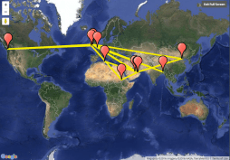
Using MP3 files and a Google map I spend a number of days walking the streets of where the modern city had been born. I researched the background of the Canadian Pacific Railways and its influential role on shaping the modern city, I explored the complex labour history including the intricate and often dark discrimination against indigenous, Asian and Eastern European workers. I had pages of information, an arduous task to select what was of most significance and interest to my student audience. The starting point of course must be a map, providing a visual context and guide. The map embodied the instructor or teacher leading the students on their walk without being physically present with them on their journey. For the transfer of information students are requested to download 18 MP3 files corresponding to a point on their map, and which take them from the UBC campus downtown Vancouver and guide them on the hour walk. Students were asked to complete a worksheet based on their experience.
I encourage you all to please try and use these resources for Vancouver and adapt them to suit your own cities. The student feedback was overwhelmingly positive: “After this walking tour, I now know Vancouver better in the Geographical, political and historical fields. Especially in the downtown area, as the commercial center of Vancouver, it combines historical and modern buildings in almost every street.This combination impressed me most in this walking tour because it demonstrates the history and development happening in this beautiful city. I enjoyed the way that we used audio as we could hear clearly without distractions” (international first year student).
Stage Two:
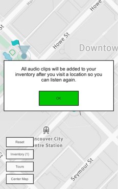
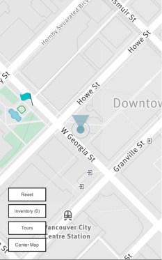
In the second year I wanted to address the two issues which I saw as an obstacles to the smooth delivery of the experience for students – that is that students were obliged to download all the the MP3 files prior to embarking on their journey. The second issue I identified was a geographical one – students needing to navigate their way in a strange city. Of course I want to encourage students to maneuver their way through the streets of the city but this can be a daunting task and can take away from the learning experience. I identified a platform, Motive.io, which allows me to easily create an interactive walking tour where content is Geo-location triggered removing the need for students to download all the MP3 files prior to the walk (this is done automatically by the app). Additionally the platform allows me to build in quizzes and supplementary information, including images and videos, which appear on the student’s phones when they reach the appropriate location. I am able to create tours using Motive.io online authoring tools; these tours become immediately available on the accompanying app on the students’ smart phones. Once again students are asked to complete a worksheet but this time they also have short interactive quizzes which appear in location. A small cost was involved in using Motive.io but this was off set by the rich interactive experience which the students have, “I feel that the walking tour is amazing, it just something like magic. When I walk to a point I suppose to go to, the audio starts speaking automatically. It is very interesting. I enjoyed it so much” (first year international student).
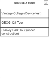
I cannot provide the app in its entirety here on the blog but below are some snapshots at how the platform works:

Which ever avenue you choose to take as an instructor or educator I spur you on your task of providing experiential learning experiences for your students whether they be historical or contemporary – providing them with the taste of the intricacy of the knowledge embedded in their everyday urban surroundings and encouraging them to embrace them.